A quick update on what to expect for the next three days as a strong jet stream brings in active weather for the West.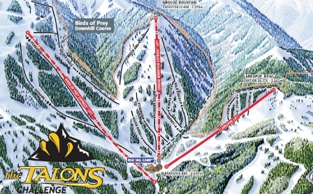
As of today, temps will remain in the 20s during the day, dropping to the teens overnight for the remainder of the weekend. Winds will be gusty and sustained in the 15-25 mph range, with gusts into the 35 mph range at the highest elevations.Snow totals look good as numerous disturbances move through the area with an associated cold front expected to drop south through Colorado during the day on Friday.
Friday morning totals should be modest, with Vail/Beaver Creek expecting 2-4 inches and Aspen/Snowmass a touch higher in the 3-6 inch range, with snow falling during the day Friday.
Saturday's totals should be much higher, although most of the snow will fall during the day on Friday, once again skewing 24-hour totals. Expect Saturday morning totals in the 4-8 inch range at Vail/Beaver Creek, with Aspen/Snowmass in the 6-12 inch range. Vail/Beaver Creek could see as much as a foot fall during the day Friday. Timing is once again the issue.
More snow during the day on Saturday, just in time for the annual Talons Challenge hosted by Beaver Creek.
Expect windy conditions and limited visibility on both the Grouse Mountain and Birds of Prey areas of Beaver Creek. Weather begins to calm a bit by Sunday, as the jet stream shifts south.
We see another active pattern by next week, with frequent shots of snow for much of early March. For now, enjoy another round of winter in the Rockies. And for those of you challenging Beaver Creek, good Luck!
Enjoy!
![]() 1 Comment on "Snowy weekend in store for Vail, Aspen"
1 Comment on "Snowy weekend in store for Vail, Aspen"


 Vail Town Council to weigh new plan to redevelop T...
  All about indexes
  Transforming your social security into a winning r...
  Pass sales, real estate transactions, revenues inc...
  Vail Valley native with passion for Biophilic inte...
  Beaver Creek starts work on new summer activities
  Land Trust, ECO Trails, Vail Resorts team up to cl...
  EUROVISION named Host Broadcaster for 2015 World A...
  Vail Resorts brings back Lindsey Vonn's 'School of...
  Hundreds turn out for 2015 World Championships vol...
  Eagle County Senior Health Expo and 9th Annual Hea...
  Final race of Vail Mountain Trail Running Series s...
  Before you write your will ...
  2015 World Ski Championships volunteer recruitment...
  Ascent Sotheby’s International Realty in Vail an...
  CDOT outlines road closures for local stages of US...
  Italian artist creates unique trophies for Vail, B...
  Vail Recreation District once again hosting Jake W...


David O. – Feb. 25, 2011, at 7:21 a.m.
Once again, Reid, you were wrong in the right way, although I'm not sure this one totally qualifies. You called for 2-4 in Vail this morning (Friday) and the official report (at 5:30 a.m.) is 5 new and it's still snowing in West Vail at 7:15. Vail just went over the seasonal average of 350 inches, topping out at 352 this morning, with two of the snowiest months of the year remaining. Can we get to 500? This weekend, with more snow expected through Sunday, should be a good start.