Powder Predictor
Potential blizzard conditions expected with tonight's storm
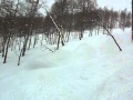
Blizzard warnings paint the Western Slope map as a brief lull will lead to an unforgettable evening. Vail, Aspen, Snowmass and the rest of western Colorado are battening down the hatches as another strong system moves into our area.
Winds will increase by this afternoon, as low pressure brings frigid temps and blowing snow. Not a lot of moisture with this system, but enough to warrant a blizzard warning by the National Weather Service, with sustained winds in the 30 mph range and expected visibility lowered to a quarter mile.
Rush hour traffic in Vail and Aspen will be affected as these winds will most certainly limit visibility, move snow, and freeze the already hated mag-chloride on the roads. On the bright side of things, we should see anywhere from 6-12 inches fall, with more accumulating snow on west- and southwest-facing slopes.
Temps for the day today will remain cold, with on-mountain highs in the teens and overnight lows below zero. On-mountain windchills will be around zero for most of today, as winds will reach into the 40-50 mph range overnight. Expect gusts into the 70's.
Wednesday will be our coldest day of the season so far, as Arctic air will be pulled in from this system and remain through Thanksgiving Day. Expect on-mountain temps Wednesday in the single digits, with windchill values in the -10 to -20 range.
Thanksgiving Day will be much the same, as high pressure builds in and keeps temps in the single digits with below zero windchills. Overall, it should be a very interesting 36 hours as travel over mountain passes will be challenging and winds will keep many older dogs awake tonight.
Looks like Old Man Winter has taken up residence in Colorado for the time being, and despite bringing the Arctic cold, he is very welcomed by all of us snow lovers.
Happy Thanksgiving, and enjoy!
![]() 0 Comments on "Potential blizzard conditions expected with tonight's storm"
0 Comments on "Potential blizzard conditions expected with tonight's storm"
Be the first to comment below.
 Vail Town Council to weigh new plan to redevelop T...
  All about indexes
  Transforming your social security into a winning r...
  Pass sales, real estate transactions, revenues inc...
  Vail Valley native with passion for Biophilic inte...
  Land Trust, ECO Trails, Vail Resorts team up to cl...
  EUROVISION named Host Broadcaster for 2015 World A...
  Vail Resorts brings back Lindsey Vonn's 'School of...
  Hundreds turn out for 2015 World Championships vol...
  Eagle County Senior Health Expo and 9th Annual Hea...
  Final race of Vail Mountain Trail Running Series s...
  Before you write your will ...
  2015 World Ski Championships volunteer recruitment...
  Ascent Sotheby’s International Realty in Vail an...
  CDOT outlines road closures for local stages of US...
  Italian artist creates unique trophies for Vail, B...
  Vail Recreation District once again hosting Jake W...