

Around the Hoop
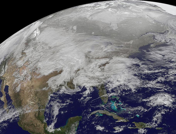
NASA satellite captures image of monster storm
But, oh, how times have changed.
It's freezing outside as one of the largest storms since the 1950s is plowing through 30 states today, dropping mercury to unbearable lows, canceling flights, snarling traffic and dumping copious amounts of snow.
Visibility on Aspen Mountain was mostly poor yesterday as the clouds gathered and unleashed sporadic snow showers throughout the day and evening. Not only was everyone wearing a shirt, but buttoned-down parkas too.
This morning the Aspen Skiing Company is reporting five inches in Aspen, seven inches at Aspen Highlands, nine inches in Snowmass and three in Buttermilk. Vail Resorts is reporting eight inches at Beaver Creek, two inches at Vail, four inches at Breckenridge and two inches at Keystone.
The National Weather Service and Real Vail's own Powder Predictor say more snow is on the way.
The storm is spanning some 2,500 miles, from the Rocky Mountains to New England.
Check out this National Aeronautics and Space Administration satellite image taken at 7:01 a.m.
![]() 1 Comment on "NASA satellite captures image of monster storm"
1 Comment on "NASA satellite captures image of monster storm"
 Vail Town Council to weigh new plan to redevelop T...
  All about indexes
  Transforming your social security into a winning r...
  Pass sales, real estate transactions, revenues inc...
  Vail Valley native with passion for Biophilic inte...
  Land Trust, ECO Trails, Vail Resorts team up to cl...
  EUROVISION named Host Broadcaster for 2015 World A...
  Vail Resorts brings back Lindsey Vonn's 'School of...
  Hundreds turn out for 2015 World Championships vol...
  Eagle County Senior Health Expo and 9th Annual Hea...
  Final race of Vail Mountain Trail Running Series s...
  Before you write your will ...
  2015 World Ski Championships volunteer recruitment...
  Ascent Sotheby’s International Realty in Vail an...
  CDOT outlines road closures for local stages of US...
  Italian artist creates unique trophies for Vail, B...
  Vail Recreation District once again hosting Jake W...


Reid – Feb. 02, 2011, at 7:58 a.m.
Mother-in-law lives in the "burbs" of Chicago and says there is 17" on the ground and drifts as high as seven feet. 70 mph winds with numerous downtown buildings damaged due to winds. Local T.V. stations aren't even broadcasting cause no one can get into the city. Crazy!!